What are participatory sensing and citizen science? How can they contribute to disaster risk management?
Oct 27th, 2014 by j0p
By Dirk Wetzlar
Due to the increasing use of sophisticated mobile personal communication devices (MPCDC), particularly smartphones, the possibilities for citizens to collect, share and combine data have increased in the last years. With features like cameras, microphones, GPS and access to internet built into MPCDC, people using them can easily gather data, combine them with their geographical location and share them with other people through the internet (Ferster & Coops, 2011, p.340). This does not only offer citizens the opportunity to contribute to research projects (citizen science) it also can lead to changes in many aspects of our everyday-life (Goldman, 2009, p.4).
However, we are just at the beginning of this process and it is difficult to see how strong will be the impact in the future.
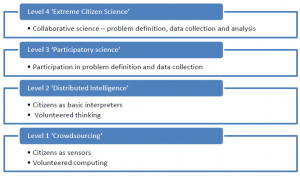
The term “citizen science” describes the participation of voluntary citizens, which do not necessarily need academic qualifications, in projects of science. Under the notion “citizen science” you can understand different activities. The categorization of these different activities can be done through the level of participation of the volunteers in the different projects, which is a really important point. The exact participation of the citizens can vary a lot of. For example Haklay (2013) introduces a participation-levels approach (Fig. 1). So, it is possible, among other things that citizens carry out the whole research project, which fits under the definition of “extreme citizen science” (level 4). On the other hand, participation in the meaning of “Crowdsourcing” (level 1) requires just a passive contribution from its participants, like to provide computing power (Haklay, 2013, p.11). Although, according to Ferster & Coops (2011, p.342), it is more common that citizens collect, process and provide data and a lead researcher exercise the main function (so called consultative/ functional structure).
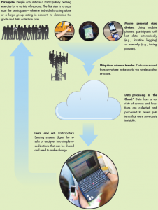
Participatory sensing is one part of citizen science, which describes in general the active use of sensors from devices like smartphones by citizen to collect and interpret data from the environment (Goldman, 2009, p.3). A chart of the process of participatory sensing is shown in figure 2. The degree of the involvement of the citizens varies within different projects. By it Goldman (2009) distinguishes three different models of participatory sensing on the basis of the participation. These are: Collective Design and Investigation, Public Contribution and Personal Use and Reflection. In the first model a group of individuals collaborate in a project and they are responsible for the entire process, whereas “Public Contribution” normally just means that citizen gather data, “but [are] not necessarily [involved] in the definition of research questions or use of the results” (Goldman, 2009, p.4). The last type, “Personal Use and Reflection”, means that the data collected by an individual is used just for his personal interest, which can help, among other things, to reflect our actions and daily routines.
Like with everything, there are as well involved in these developments certain possibilities but also risks. Really positive is the increase public knowledge and interest for science, which results from the participation of citizen. Also it is possible to collect data for a bigger spatial expansion and with a higher temporal frequency, which play an important role in disaster risk management (Ferster & Coops, 2011, p.341). However, a critical point is the privacy and the security of the collected data. On this matter Goldman (2009, p.6) argue, that in the use of sensing systems should be as much privacy as in other parts of our live. Another point is the accuracy of the data, provided by citizens. Although there are empirical analyses, which are showing that volunteers can work as accurate as professionals, there might arise some errors, due to technology, training or intention of the citizens. Therefore, the more people participate in projects, the more accurate data can be expected (Connors, et. al, 2011, p.1282).
Citizen science and participatory sensing can contribute to disaster risk management in a lot of different ways, above all by their strengths which are mentioned above. They can be useful not only during the disaster, but also before and after it.
In general through the participation of citizens in science they might get aware of existing problems, after which ideally the individuals act to reduce their vulnerability. Also people take part in participatory science projects can help with their local knowledge.
The strength to gather data for a big spatial expansion is especially useful, if there are widespread phenomena, like Wald (2011) shows in his paper for earthquakes. Through this project, it was possible to collect information about the distribution of shaking intensity for the entire USA, which “we have never been able to show before” (Wald et al., 2011, p.694). With this information scientists may get a better understanding of the subject.
The strength to provide, through the participation of numerous people, a big amount of data, which is up-to date, is for example essential in case of destruction. Keeping in mind that the gained data are from the ground surface, participatory sensing can perfectly replenish gathering data from remote sensing.
Goldman, J. et al. (2009). Participatory sensing: A citizen-powered approach to illuminating the patterns that shape our world, (May), 20. Retrieved from http://escolarship.org/uc/item/19h777qd.pdf
Connors, J.P., Lei, S. & Kelly, M. (2012). Citizen Science in the Age of Neogeography: Utilizing Volunteered Geographic Information Monitoring. Annals of the Association of American Geographers, 102(6), 1267-1289. Doi: 10.1080/00045608.2011.627058
Ferster, C.J. & Coops, N.C. (2013). A review of earth observation using mobile personal communication devices. Computers & Geosciences, 51, 339-349. Retrieved from http://www.sciencedirect.com/science/article/pii/S0098300412003184
Haklay, M. (2013). Citizen Science and Volunteered Geographic Information – overview and typology of participation in Sui, D.Z., Elwood, S. and M.F. Goodchild (eds.), 2013. Crowdsourcing Geographic Knowledge: Volunteered Geographic Information (VGI) in Theory and Practice. Berlin: Springer. Pp 105-122 DOI: 10.1007/978-94-007-4587-2_7
Wald, D.J. et al. (2012). USGS „Did You Feel It?” Internet-based macroseismic intensity maps. Annals of Geophysics, 54(6). doi:10.4401/ag-5354


Thanks for the clear and brief summary of this large topic!
As the main point of citizen science lies in the participation of plenty of individuals in the Sensing, we have to encourage most people as possible to take part. One of the biggest barriers of participating besides the access to devices and simpleness in practice is privacy. As you pointed out correctly, it constitutes a critical point in the whole discussion because all other questions are based on that: Who participates in collecting data? Who takes part in the analysis of data? And who can use the results in the end?
Since Citizen Science and Participatory Sensing take place in public, people want to know their personal data is safe. But who can guarantee security? In my view only the participants themselves can because they are the beneficiaries and owners of the collected data and have the right to decide on the use of the data. Due to that it is important that there are self-organised non-profit groups of participants who ensure other participant’s privacy by managing the project. In this point, everybody of us can play an important role because we have the possibilities and the knowledge to collect and to analyze the data and to visualize the results. In this way we need to be aware that the whole concept is based on the participants and the better we can guarantee data privacy and security, the more will participate.
I think this is a point which will be further discussed in public and also in one of our sessions.
Regards,
Julia